EttinCon Mega-Map (Part 4)
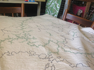
Today was the start of painting the mega-map. The whole thing takes up the full table in the art studio, even when it's been extended to maximum size.
Before doing anything else, I need to add the latitude and longitude lines, but I certainly don't have any compass large enough to draw the arcs.
So, it's time to measure things out and pull out the string.
Next...colouring...
I've decided that I'm going to use a watercolour technique for the map. If I used heavy acrylics, or even put a coating of primer on it, it would become more difficult to sew things onto the canvas...which is one of the long term goals of the project. Using watercolour will function more as a stain on the canvas, so it might take a couple of coats to get a good rich colour happening...but we'll see how it goes.
First I'll tape some plastic sheeting down on the table, this will make sure the watercolour doesn't sink through the canvas and into the wooden table.
I've had these watercolours lying around for a year or so and have been meaning to use them, so this project seems like a good time to open them up.
First I put some water down on the canvas with a thick brush, not quite soaking the canvas, but making sure it's damp enough that when I apply colour it will spread and easily be blended.
Here's a video (sorry, I didn't realise that my hand was in the way as I filmed it).
Step by step, working through the coastlines...


.png)

Comments