EttinCon Mega-Map (Part 2)
This map is pretty loose, it's for a blank slate world that will be defined as we go. But it's nice to have some hooks for players to latch onto, and for GMs to base adventures around. I've been given a rough framework (as indicated in the last post), but pretty free reign with specifics.
Here's the working sketch.
Here's the working sketch.
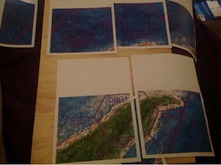
Or, more accurately, here are the pages on which the rough sketch has been printed, scaled up to be more impressive.
Due to the printing on A4 pages, I need to guillotine the edges...
Then tape the fragments together...
...gradually building the complete map.
I've discussed fractal hexes before, in my geomorph series a few years ago. So it's nice to see a map given to me where this system is in place. Four of the smallest hexes across make one of the mid hexes, four of the mid hexes across make one of the large hexes, four of the large hexes make one of the largest hexes.
This works as a fairly convenient scale for the map, because I've been told that is should take roughly six months of constant travel to get from one end of the map to the other. If it takes a full day to travel across one of the smallest hexes, it takes just over half a week (four days) to travel across a mid hex, just over a fortnight (sixteen days) to travel across a large hex, just over two months (sixty-four days) to traverse one of the largest hexes, and the whole map is just over three of these largest hexes in height...so that basically gives us just over 6 months (specifically, 192 days, but let's say 200 to round things off).
If the standard metre is based on the radius of the earth, where 10,000 km is the distance from the equator to one of the poles, it might be feasible to suggest 7500 kilometres between the equator and an arctic/antarctic circle on an earth-sized world. That also suits our purposes. 7500km divided by 200 days gives us 37.5km per day... which is a reasonable travel distance as a typical horse travel can be almost twice that. Of course, walking will be significantly less. This means a mid sized hex is about 150km across.
Which means that is a massive ferret!
Butmore seriously, it means that the i tended world of the setting is roughly Earth-sized and therefore I need to consider this scale when I draw the coastlines for the map. Wide beaches would be no thicker than the width of a fine drawing pen, rivers would need to be more than a kilometre wide before they'd be significant on the map... so we'll take a bit of artistic license on them. They certainly won't be asthick as the rivers currently depicted which would each be in excess of 100km wide.
The canvas I have to work on for this project is lmost exqcly the size of the map offered. So I now need to reconsider the circular map idea. If I were to continue taking that path, a lot of details around the edges of the map would be lost.
This is one of the larger maps I've worked on, and I don't have a lightbox big enough to trace the sketch onto the canvas, so I'll make do with a variant... the back door. That means I need to work through this stage while I've got daylight on my side.


.png)

Comments